

For a leisurely day’s cycling in Greater Christchurch, you can’t beat the eastern side of the Waimakariri district. It’s easily accessible via the shared pathway along the Christchurch Northern Corridor and is well-served by a growing network of cycle tracks.
I like to do a big loop north to Kaiapoi and up the coast through the small beach settlements to the Ashley/Rakahuri River, before heading inland to Rangiora and back through Kaiapoi. It’s a flat and easy ride, and offers varied terrain and great scenery. In my view, it’s easily as good as some of the Great Ride trails in other centres (such as the Hawke’s Bay and Nelson-Tasman regions).
My ride starts with a brisk warm-up along the sealed path by the Christchurch Northern Corridor (which I’ve described before) and on to the connecting path to Kaiapoi at Tram Road. The path takes you off-road as far as Isaac Wilson Road (roughly opposite Blue Skies) and then through quiet back streets to the centre of town. The route is well-signposted so you won’t get lost. Once you get to the Kaiapoi River, turn left if you want to go to Rangiora; turn right for Kaiapoi’s town centre.
If you’re familiar with Kaiapoi, you’ll know the town centre occupies a pretty spot by the banks of the Kaiapoi River. While the town was badly damaged in the Canterbury earthquakes of 2010 and 2011, the earthquakes provided an opportunity for rejuvenation. There’s a new museum and library, several new cafés and restaurants, and walking and cycling tracks all designed to make the most of the river setting.
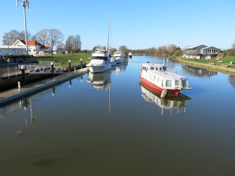
For many Christchurch cyclists, Kaiapoi is the destination. There’s a Coffee Culture by the river that is very popular with cyclists, and cycling groups are well-catered for at the Rivertown Café (back along Williams Street), which is run by a community trust and has plenty of bike parking. Paris for the Weekend attracts locals and visitors for coffee, high tea and brunch, and has just shifted into a sunny new location on the northern riverbank.
Back on the bike, the shared path on the northern side of the river takes you past the confluence with the Waimakariri River towards the river mouth and the sea. This is one of the most scenic parts of the ride – with sweeping views of the river and beyond to the Port Hills. To the west, you get a great view of the Southern Alps – looking particularly stunning in winter with their snow caps on.
The path is gravel at the Kaiapoi end, but becomes a dirt track part way along (so can get a bit mucky after wet weather). There are two styles to cross – one near the not-so-scenic sewerage ponds and the other at the end of the track at Beach Road. They aren’t difficult but you do need to be able to lift your bike (or bump it over the steps).

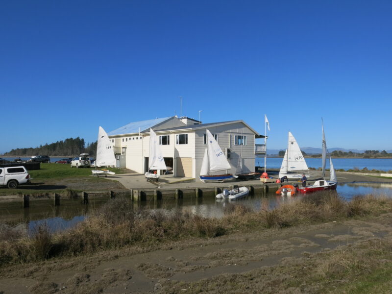
It’s worth a short detour to Kairaki and the river mouth when you get to Beach Road. The river mouth is a popular fishing spot, and there’ll often be people with fishing rods lined up all the way along the northern side at Kairaki (and dotted around other places along the riverbank). There’s a small yacht club here and, in summer, there’ll be jetskis on the water too.
From nearby Pines Beach, you can take the shared cycle/walking track through the Tūhaitara Coastal Park all the way north to Waikuku Beach, passing by Woodend Beach and Pegasus along the way. There are several access points to the track but they aren’t immediately obvious. You can access the track via the eastern end of Beach Road or cycle on a bit further and head up the roads behind the houses, and you’ll find an access point.
The terrain and surroundings vary along the track – initially, it’s an easy (but sometimes mucky) dirt track through pine forest. From Woodend Beach, it’s a chunky gravel path through low scrubby bush and past Tūtaepatu Lagoon. North of Pegasus, it’s a finer gravel track all the way to Waikuku Beach. While a coastal track, it’s set back from the sand dunes so you can’t see the sea while you’re cycling. But there are plenty of places you can access the beach – and there are public toilets, playgrounds and picnic areas at every stop.
Pegasus makes a good detour spot for coffee – just head left when you reach the sealed road (turn right for the beach). But I usually carry on to the Ashley/Rakahuri estuary at the northern end of the Waikuku Beach settlement. It’s a relaxing spot to take a break before heading inland along the Ashley/Rakahuri River to Rangiora. (There’s a small store at Waikuku Beach but I’ve never stopped in so cannot vouch for its services.)

From the estuary, you have a choice of cycling along the stopbanks or taking a mountain bike trail through the bush by the river. The stopbanks are the quicker and easier route. It’s a wide open space, with a great outlook over the surrounding farmland. But the mountain bike path is more fun, with lots of ups and downs and corners. Fortunately, there are plenty of connection points between the tracks so you can mix it up.

Either way, you’ll cross State Highway One by going under the bridge. The tracks end in slightly different places. On the mountain bike track, you will find your way through to the Ashley Picnic Ground (another good stopping point). With the stopbank route, you’ll need to take a gravel road to get back to the same point – or exit onto East Belt instead.
From the Ashley Picnic Ground, I take the main road all the way through Rangiora to the other end of town (Southbrook), where I can connect up to the shared path back to Kaiapoi (the Passchendaele Memorial Path).
Cycling through Rangiora is probably my least favourite part of the ride because it’s a busy place with lots of traffic. But there is an on-road cycle lane for most of the way and it’s possible to take quieter back roads instead. There are also plenty of cafés and shops (and a movie theatre) if you want to take the time to look around. It’s a lot more relaxed once you’re off the roads and wandering around the town centre.
The Passchendaele Memorial Path to Kaiapoi is a separate shared path that runs next to the railway line and passes through farmland. It’s an easy sealed ride, with the main hazard being a flock of chickens that like to hang out on the path. Coming into spring, you might need to watch out for the odd magpie.
Close to Kaiapoi, the path veers in towards the river and follows the river back into town (take the narrow pedestrian bridge over the river). From there, it’s a gentle ride through the back streets and on to the path back to Christchurch.

All up, it’s roughly an 85-kilometre loop from central Christchurch, and takes a good four hours or so of cycling (depending on how energetic you’re feeling). If you’re taking it slowly and making lots of stops, it’s a full day out.
Some options
- If you’re cycling from north Christchurch, you’ll shave about ten kilometres off your ride. (Of course, it will be a much longer ride if you’re coming from the south of the city.)
- You can shorten your ride further if you take the bus or drive to Kaiapoi and make that the start and end of your journey.
- Another option for a shorter ride is to cycle as far as Kairaki and then loop back to Kaiapoi along Beach Road. There’s a gravel cycle track next to the road.
- You can also exit at Woodend Beach and take a cycle path back to Woodend (the Jill Creamer Trail), cross the main highway and connect to another cycle path to Rangiora (the Woodend-Rangiora Path). But that’s not as scenic as taking the Waikuku Beach and Ashley/Rakahuri River route.
- You can cycle the route in either direction. I used to do a clockwise ride, heading to Rangiora first and then coming back along the Ashley/Rakahuri River to the coast and down to Kaiapoi. But I think the views are better in the other direction, and I completely missed seeing the Tūtaepatu Lagoon until I started cycling this way. (That finally explained why there is a small lookout point!)
- The Waimakariri District Council plans to build a new cycleway from Kaiapoi to Woodend township in 2024 – so that will open up other options.
There’s also a good cycleway between Rangiora and Woodend that follows alongside the Rangiora-Woodend highway.
And from Waikuku Beach, an option is to take the quiet Kaiapoi Pa Road through to Pegasus (there are a couple of access paths into Pegaus near where Kaiapoi Pad Road becomes Preeces Road). Then take the pathway between the gold course and western edge of Pegasus township, all the way through to Gladstone park, where you can pick up the cycleway through to Woodend.
Will be great when the Kaiapoi to Woodend cycleway is complete!
Another great cafe in Kaiapoi, much loved by us locals, is Red Eight. Located on corner of Williams and Charles St, opposite the fabulously restored and repurposed historic BNZ Building. You can park your bike around back in the car park.
Yes, I love going out this way. Used to live in Rangiora, so explored the routes well. Nice to go back there for day rides.