The street works around the central city continue to materialise fairly quickly, and just as quickly are the consultation plans for the next ones. A few months ago we saw the planned changes to Hospital Corner, Durham St, and Manchester St (I’m happy to report that the revised tweaks are mostly an improvement on the original plans); now it’s the turn of St Asaph Street from Ferry Rd to Antigua St.
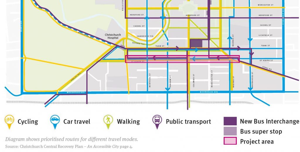
We’ve already seen Tuam St get the separated cycleway treatment in the easterly direction. Now we get its westerly partner running along St Asaph St. This will help to connect to Ferry Rd, CPIT, and the Eastern Frame at one end, and Hagley Park, Antigua St, and Hagley Ave at the other.
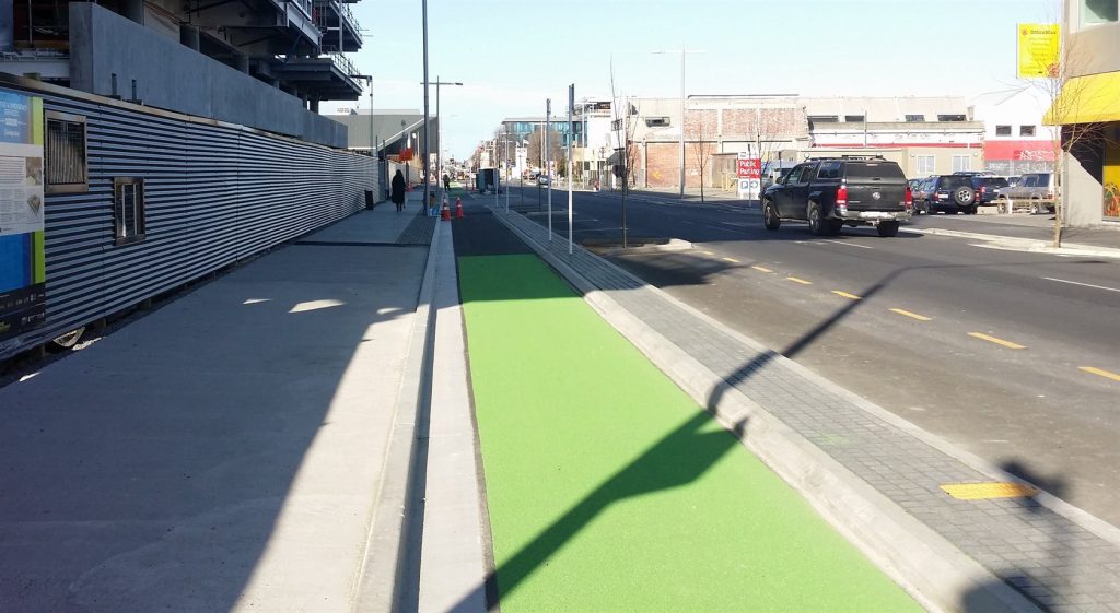
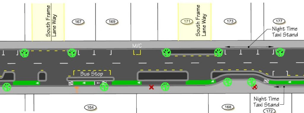
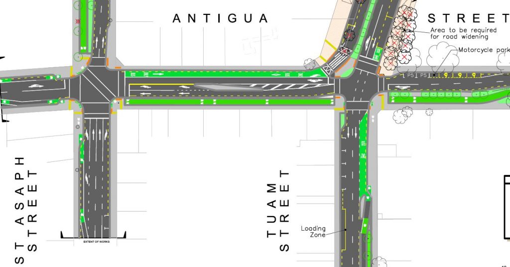
Most of the route will see a 2m-wide one-way cycleway run down the street, separated from the car-parking and traffic lanes by a concrete berm. There will be some car-parking removal, although much of that is for new street trees rather than due to the cycleways. Coloured surfacing highlights where driveways cross over the cycleway. At the intersections there are also a few hook turn boxes, and I would expect that (like we’re seeing on Tuam St) the cycleway will get a protected signal phase with left-turning traffic held back.

There are nice little details evident, like the raised cycleway where it crosses behind a bus-stop. It’s also great to see some new bike-stands proposed at regular locations on the kerb too (although a few more could be placed on some of the berm islands). One thing not quite clear to me is how a person biking can access the new South Frame laneways on the other side – are there kerb ramps or street crossings there?
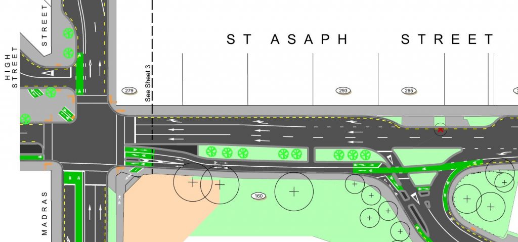
Near CPIT, a two-way section of cycleway will allow riders to link between High St and Ferry Rd. This will provide a useful connection for those wanting to get to/from CPIT and points further southeast. A cunning diagonal crossing at Madras St will help with this, although it’s not clear to me that it will easily connect to the popular shared path running down Madras St towards the Rakaia Building entrance.
As mentioned above, the connection from this cycleway to the streets near Hospital Corner will now be much improved, as reported recently to Council. Two-way off-road cycleways will run along Antigua St to the river and St Asaph St to Hagley Park, with special signal phasing to get them across the intersections (hopefully reasonably efficiently). It’s particularly great to see the separation from the pedestrian ways here, after the original proposals had shared paths everywhere.
If you want more information, there are also a series of public information sessions:
- Wed 23 Sep, 12-2pm in the BNZ Lounge, EPIC (cnr Manchester/Tuam)
- Sat 26 Sep, 2-4pm in the foyer, Christchurch Central Police Station (68 St Asaph Street)
- Thu 1 Oct, 12-2pm in the BNZ Lounge, EPIC (cnr Manchester/Tuam)
Consultation on this current plan closes 5pm Thu 8th October, so have your say before then. While not a particularly complicated project, it’s good to see that the quality of what is being provided is slowly improving and generally addressing most of the little detail niggles of earlier plans.
What do you think of the proposed St Asaph Street works?

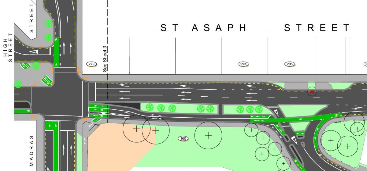
I do wish the maps had a North arrow on them.
Also passing on the left side of a parked car gives me the heebie jeebies. Have almost been doored by a passenger on a one-way street not thinking. So I ride on the left of one-way streets now, and I avoid Tennyson street totally.
The plans found on the CCC site do have North arrows- http://www3.ccc.govt.nz/CCC.Web.ProjectInfo/cityleisure/projectstoimprovechristchurch/projectinformation/projectsearch/projectview.aspx?projectid=4864
Yeah, you can blame me for taking small extracts of each plan. They’re all north at the top, except for the Antigua St one (north to the right)
No need to worry about passenger car doors; there’s a metre of berm between you and the parked cars (have a look at the photo)
To be honest you’re more likely to be door riding past the drivers door many cars are single occupant. Plus in a worst case, at least the door won’t knock you into the traffic stream.
Until an entire generation has grown up with the idea of “look behind before opening car door” its always a risk. How do you expect passengers to think about their surroundings, when its hard for drivers? Defensive Biking or Defensive Cycling – its a real thing.
“How do you expect passengers to think about their surroundings, when its hard for drivers?”
I don’t think they will to be honest. As you say, it’s hard enough for most drivers. There needs to be increased road safety advertising which highlight things like looking for cyclists before opening the car door. Until then, I’m sure we’ll all have to continue to be on our guard.
I think the plans look great, especially all the new street trees being added. Tuam Street is looking fantastic after some recent tree plantings- it’s amazing how some trees can give the road a much more pedestrian and cycle friendly space- the quality immediately improves.
The diagonal crossing into High St and the contra-flow cycle lane to Ferry Rd are both great, making it easier and faster taking a bike compared to a car. The earthquakes have given our city such an opportunity to make a bike-friendly city- with each set of plans coming out I think we’re getting closer to it!
This is looking good, however I do agree 100% about the lack of easy access from the north to CPIT Madras Street eastside campus without priority linking to the shared pavement pathway. I will forward a photo taken recently in Rotorua showing how separated bike pathways are directed onto the footpath at intersections. Perhaps it could be feasible here.
You mention the popular shared path outside CPIT on Madras Street. Unfortunately CPIT has removed (asked to have removed? but anyway they are gone) the cycle markers off the footpath outside CPIT on Madras Street (Moorhouse to St Asaph) I assume because a pedestrian got hit by a cyclist and complained. Great to know that they will be coming back. However, because 100’s daily (truly 100’s) cross Madras Street from W to E onto the footpath between parked cars and don’t look for cyclists on the path accidents are bound to continue to happen. Signage on the West side might be useful.
And a more general question. My son (rides a racing bike) and I (rides a commuter bike) had a look at the new cycleway section on Colombo St outside the new bus interchange while walking into town and we were both mind-boggled by the stupidity of aligning the lovely wavy gaps in the draincovers parallel to the direction of travel. The chances of catching a tire in one of them is way more likely than catching a tire in tram lines (and that hurts enough) and there were 2 in the one block. Is this being corrected at all?
I think you’ll find that the wavy shape and the narrow slits mean that even a road-bike tyre would struggle to get caught in these drains. But I agree that they look menacing and could have been done better.
The planned markings and kerb ramps seem to imply that the Madras St path will continue to be a shared one. But they never really completed the full works they were going to do along here to make it a comfortable shared facility, before the quakes came along.
CCC staff believe that these grates are cycle friendly (I know because I asked them). I do not concur.
Segregation is good but I don’t want to be trapped segregated. I hope there’s an ability to move across to right BEFORE intersections and do not HAVE to use hook boxes.
eg Currently if riding east on Tuam & wanting to go to Sydenham you’re stuck seperated on left until you get right to Colombo St. Even if the traffic is light you’re trapped to left of the raised concrete barrier as there’s no gaps to ride through to get across to turn right. Because of this I now move over the right of the road two blocks before Colombo. So I’m, leaving the safety of the seperated cycle lane two blocks early so that I can turn right at Colombo, or more frequently I now turn right into Durham St South then left into Bath to get me to Colombo & Sydenham. Drivers will no doubt abuse cyclists for not using cycle lanes. Can’t win. Bonus of being on right though is I’m right beside or in front of drivers so they do seem to give more passing room.
Not being able to turn right into St Asaph St from Madras St and across to ferry Rd then right into Williams St to get to CPIT student car park in Coventry St is sooo inconvenient, It works fine for cars and bikes, “if its not broke dont fix it !!” Otherwise to go up Madras St and Rt into Tuam then Rt into busy Barbadoes st, will take atleast 15mins longer, because of Rd works,by Tuam (One lane) plus extra fuel to go that way. Its hard to comprehend what the person that thought of this plan was thinking, certainly not to make driving easier for people.
15 extra minutes to travel an extra 400m by car? I don’t think so. And the Tuam roadworks will probably be finished before this work is undertaken.
I guess you come through the Moorhouse/Madras intersection? From there to the carpark is 700 metres. If you go via Moorhouse/Fitz/Ferry/Barbadoes then its 1.3 km, for a net extra of 600 metres.
Can you find a more-acceptable carpark?
Or do remember that there’s cycle parking right by the door, all over CPIT. This being “cycling christchurch” blog not-subtle
In part I agree with you but isn’t that the fault of the one-way system ? . If only that could be re-worked so that each transport choice had equal priority then the city would be more accessible for everyone.
yes definately
CPIT car park in coventry st cost $2.00 a day for students, and those who study at Te Puna Wanaka use it., an I am too old to ride a bike
You’re never too old to ride a bike. If its physically challenging as the years stack up how about considering an ebike? The electric assistance removes any physical limitation excuse.
I prefer comfort and warm of my car, thanks for ur S, A comment, have a nice day :0
No sass intended, but, why are you commenting on an cycling advocacy web site if you don’t ride?