

Greetings from somewhere down the Waitaki Valley! Yes, I’m currently busy biking the Alps2Ocean cycle trail; will give you a full rundown about it on my return. The A2O is part of a growing network of off-road and on-road cycle touring routes around the country; as this network expands, people will have more options for how they might get around by bike. But that may still require some means of knowing how to find your away around… Back in Jun 2019, guest contributor Jan Jakob Bornheim thought about how we might apply a relatively simple route navigation system to the cycle networks beyond Christchurch…
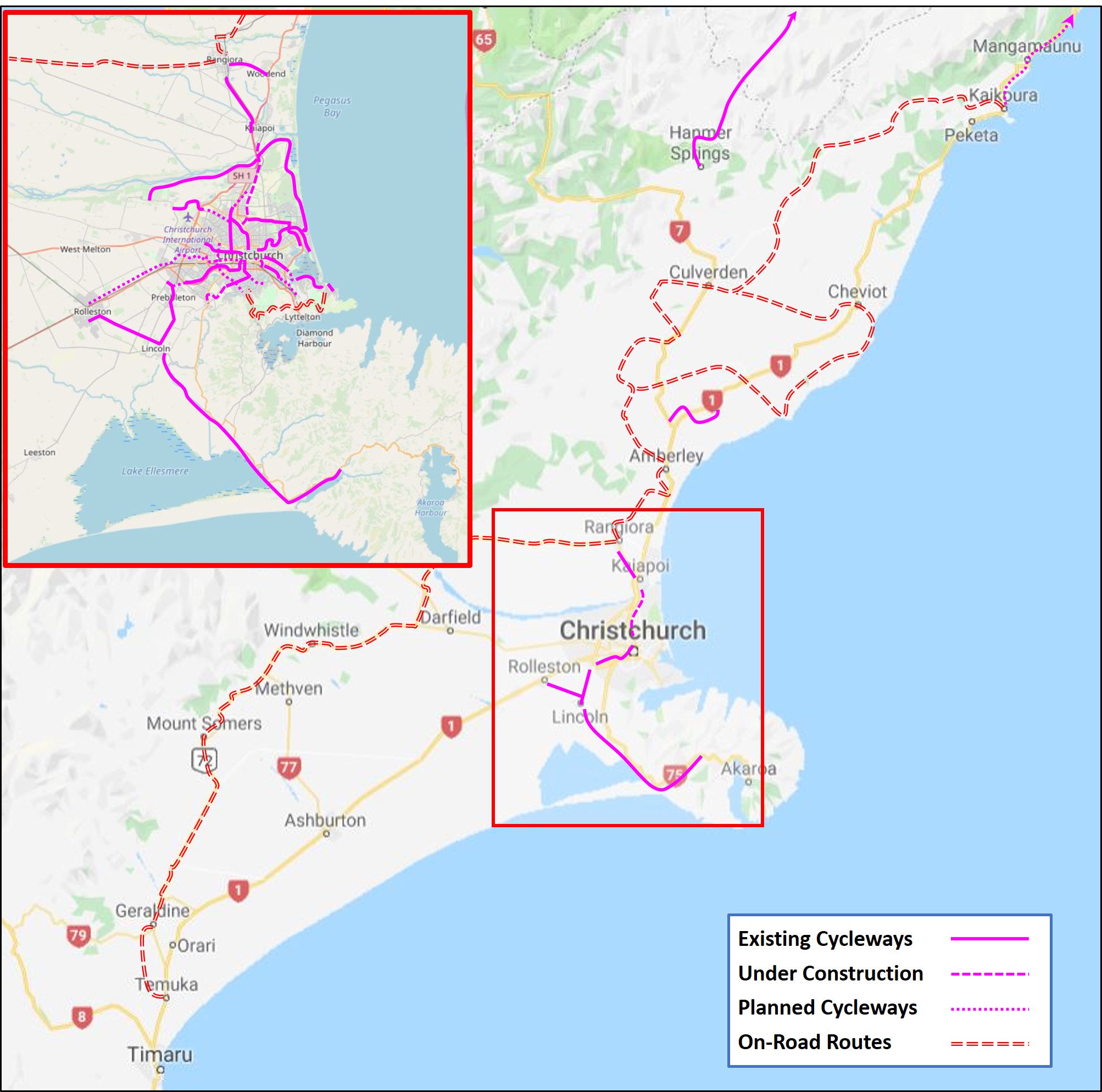
The Christchurch Major Cycle Ways are a success in moving people riding their bicycles around Christchurch. But in the last few years, it seems there has been another, quieter evolution in cycling in Canterbury: the genesis of a regional cycling network in the Greater Christchurch region.
In a few years’ time, with the completion of the shared path along the Christchurch Northern Corridor, the missing link for the Little River Trail as part of the Southern Motorway works, and the Coastal Pathway, it will be possible to bike between Rangiora to Little River and from Rolleston to Sumner on cycle-friendly facilities.
This regional cycle network does not only benefit commuters (realistically speaking, on an e-bike one could commute from Kaiapoi to the CBD soon). A few years down the line, it should be possible to go all the way to Picton and connect with trails in the Hurunui along the way. The benefits of this should not be under-estimated: the national cycleway has benefited communities along it immensely.
Such a boom is possible for businesses in Canterbury as well. I recently had family come over from Europe, and they enjoyed the West Coast, the Alps, and taking the train and ferry to Wellington. But one of the highlights of their visit was a simple bike ride along the Papanui Parallel, the QE2 shared path along the Travis Wetland, and the Te Ara Ōtākaro Avon River Trail, finishing with a nice afternoon pint at Pomeroy’s (come to think of it, three out of four times I go to this particular place, it is because it is at the CBD end of the river trail and the perfect end-point for a casual Sunday afternoon cycle ride).
Topographically, riding your bike in the Canterbury Plains is just like riding your bike in the Netherlands, except the scenery is more spectacular. But it doesn’t only attract international tourists. A regional cycle network attracts domestic tourists and creates incentives for day tours by Cantabrians exploring their region by bike.
But looking at a map, it is not always straightforward for the interested recreational rider to see how, for example, taking the Passchendaele Memorial Path, the Northern Corridor, the Papanui Parallel, the City Promenade, the Little River Trail, and the Lincoln-Rolleston shared path all will connect with each other to make a continuous journey from Rangiora to Rolleston on a bicycle possible. A regular commuter will know their way, but the weekend tourer might not.
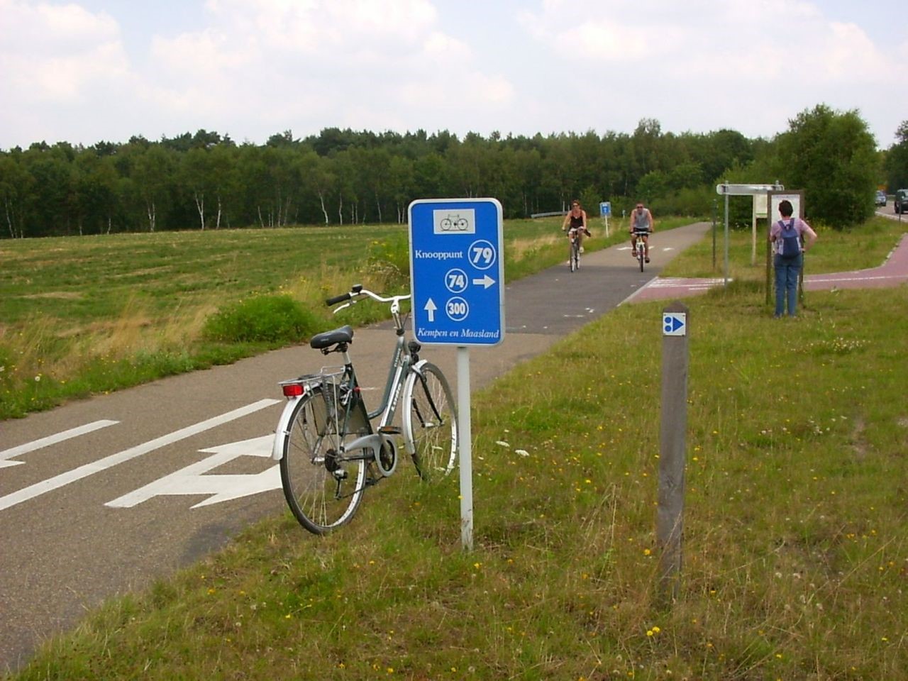
This is where the idea of a regional cycle node network comes into play. These systems exist for example in the Netherlands, Belgium and the German state of North Rhine-Westphalia. In such a system, every crossing point between different cycling routes (i.e. each node) is assigned a number. The nodes are signed, and at the nodes and along the routes, signs indicate which next node can be reached by following the cycle facility in this direction. Cyclists can then easily plan a route by connecting the nodes.
The connection between the nodes – cycle paths, shared paths, or cycle-friendly roads with or without cycle lanes – are shown on a map and where necessary and practicable, signs are erected along the connectors as reassurance signs to reassure people riding their bikes that they are on a connector and which node they are moving towards. The node network works particularly well to plan a route on the computer (see for example the Limburg node network), and some route planners allow you to export a planned tour as a GPX file for use with any smartphone or other navigation system (for example, the North-Rhine Westphalian cycle travel planner).

But it doesn’t have to be that technical. A person wanting to travel from Rangiora to Rolleston along a certain route would simply need to write down the numbers of the nodes along the way and then follow the signposts.
In such a system, every point where major cycle ways or other cycle facilities meet would become a node. But the node network system does not require the connection between nodes to be a dedicated cycling facility. For example, the network in the German region of Viersen (PDF) clearly shows that a number of cycle-friendly roads have been marked as node connectors. The same could be done in our neck of the woods to signpost people who are riding through Kaiapoi in order to connect from the trails in the Waimakariri District to the new shared path on the bridge and the CNC shared path, or to close the gap between Halswell and Prebbleton (with the new speed limits, Sabys Road will be a cycle-friendly connection between Halswell and Prebbleton).
Ideally, a website that shows people the node network would be colour-coded to show the different types of cycling facilities (cycle path, shared path, cycle-friendly road with or without cycle lanes, unpaved trail) that act as connectors between the nodes. The investment required is not huge. A website and some information material promoting the network, clear signs along the way to signpost the connectors between the nodes as well as the nodes themselves, and maybe some paint on the cycle-friendly roads alerting other traffic participants about the presence of cyclists. It would also require a degree of co-ordination between the different road authorities. In return, I am looking forward to spending my money along the way on sustenance.
What do you think? Is a regional cycling node system worth exploring?
Here a really basic map project I put together playing around looking for rides
https://sfcnzl.github.io/Mapping/map-ol.html
it leverages openstreetmaps data along with some open sourced librarys to show cycle routes and infrastructure.
https://www.pastoralsystems.co.nz/photography/wordpress/wp-content/uploads/2024/01/WW-Rides-144.png
With thanks to Peter Harris from Pastoral Systems, this map is an overlay of the Wednesday Wheelies Bike Group routes.