
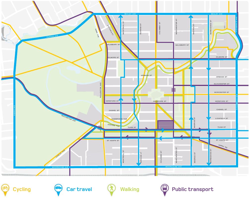
If you think about all of the features of the new central city (including the “controversial” ones like St Asaph St and the 30km/h speed limit…), then they had their genesis in a transport plan released seven years ago by a Government-appointed agency (some might argue that this was inspired by an earlier plan proposed by Danish urban designer Jan Gehl, which had been quietly shelved before the quakes…). This grand vision saw a rebuilt city centre that provided a much more multi-modal palette of options and a few dramatic changes in the pre-quake transport network. Back in Nov 2012, we reported on the draft plan out for consultation and its implications for biking in Christchurch…
CERA released its draft central city Transport Plan “An Accessible City” last Thursday (hmm, just before a holiday weekend – trying to bury things?). This follows on from the Central City Blueprint that we saw a little over 100 days ago. It contains some quite bold plans for transport in Christchurch, such as changing some of the one-way streets and priority bus routes – so what’s in it for cycling?

Here’s a rundown of the good, the bad, and the “interesting” as best as I can see:
- There are a number of new (traffic-free) pedestrian zones, such as Cathedral Square and along much of the Avon. Excellent! What’s not entirely clear is whether cycling will also be able to take advantage of these routes (and preferably with some level of separation in places). For example, there are a lot of cycling lines all leading into the Square, but can you bike across it too? Interesting too that cycling only seems to be shown along the true left bank of the Avon…
- A key feature will be the 30km/h central city zone covering much of the inner core. This is one of those little sleeper things that tends to get ignored in the rush to look for new cycleways, but actually shouldn’t be underestimated in helping to (a) discourage unnecessary motor traffic and (b) make cycling far more comfortable and safe with the remaining slow motor traffic.
Still, there is the danger that it is viewed as the panacea for all things cycling within this zone, when it may still be appropriate to provide some separate cycling provision in places. Someone pottering along at 15km/h on their bike may find it pretty daunting to have a lot of traffic backed up behind them. And, as we saw briefly on the newly reconstructed Hereford St before the quakes hit, it’s a bit of a pain to be stuck in congestion on your bike but not be able to get out of it because the street is too narrow…

- Key cycling routes have been identified across the city. The Plan suggests that these could be a mix of treatments, from separated cycleways (separated from pedestrians as well) to just sharing with other traffic in the 30km/h zone. Hopefully there might be the opportunity to implement some neighbourhood greenway treatments too. Intersections along these routes will also be designed to ensure priority and safety for cycling as well. So all this sounds really great for cycling (in theory at least).

- Those key cycling routes include parts of Colombo, Victoria and High termed “Main Streets” in the Plan. Although they are to be “prioritised for walking and cycling” and slowed down to 30km/h, they also tend to carry many of the priority bus routes and have no real restrictions on motor traffic it seems. The artists’ impressions show people simply cycling in the traffic lane with everyone else; again I’m not sure that a lot of the “interested but concerned” are going to buy that.
- Some of the suggested routes seem a little odd as they head out of the city. I mean, why would key cycle routes head for busy Riccarton Rd and Fendalton Rd west when many people prefer something like Kilmarnock or Matai St? Once in town too, a number of routes seem a bit disjointed. For example, the busiest cycle route in Chch is probably the Armagh St bridge at Hagley Park, so should Armagh St be an east-west cycling route? (it’s not designated for anything else in the Plan)

- The plan says that “cycle parking facilities will be provided at convenient locations” – this includes secure bike parking in conjunction with the new Bus Interchange and “super stops” (hmm, access using your MetroCard perhaps?). Private developers will also be encouraged to provide their own bike parking, but it would be nice to see a plan of where the City needs to front up with its own bike parking (either with public facilities or near other key destinations). I mean they’ve taken the time to show where the car parking will be…
- A nice feature proposed is improved way-finding signage around the city including cycling routes. Hopefully this will be good at highlighting key cycling destinations and where good bike parking is.

- What needs to be explained further is exactly how cycling is provided for if your desired destination isn’t actually on one of the key cycling routes. That might not be a big problem if it is in the 30km/h zone or on a local street, but what about the one-way streets or Four Aves for example? Although nothing was mentioned in the text, it was intriguing to see this mock-up of a new one-way street that seemed to feature separated cycleways on both sides. Could we actually see two-way cycling provision along these routes?

- For motor traffic, the existing one-ways are largely identified as the main ways to get through the city (with even more preference given to travelling along the Four Aves if your business is elsewhere). However there seems to be little to actively discourage drivers from using the remaining non-arterial streets around town (other than the 30km/h limit). As it stands, I could drive right across town on a street like Manchester or Hereford; yet presumably that’s not what is intended. I understand the need for access by car to destinations and parking, but I don’t see why those same streets should also provide complete thoroughfare. Perhaps a few strong “breaks” in the network (with walk/bike bypasses) are needed to really encourage drivers to use the road hierarchy properly.
CERA has given people until February 1st 2013 to provide feedback on this Plan; it’s not clear whether the democratic process extends to having hearings or anything (CERA seem to be strangely immune from such public accountability requirements…). Nevertheless, it’s pretty important that you have your say and let them know what you like and dislike.
Has the draft Transport Plan materialised as you expected?
The plan, developed without input from people who actually cycle, was not that flash for bikes. Even worse it did not provide for commuter cycling.
The Major Cycle Routes are fine, but we desperately need to have them completed and hooked up with great local cycle networks. Council will need to keep hearing from lots of us that we want this. Right now they seem to think they have done enough and it is time to put the money into public transport.