
This week a notable event in active mode guidance occurred with the launch of Waka Kotahi NZTA’s Pedestrian Network Guidance (PNG). This updates best practice advice (at least 12 years old in most cases) for planning/design for walking in NZ. Not surprisingly, it has a lot of connections with advice for cycling as well, especially where they have common issues like speed management and road crossings. One area where the thinking has evolved a lot in recent years is over the question of shared paths, and the PNG has plenty to say about these. In brief, while they have their uses, they shouldn’t be a default option where plenty of people walking, biking, wheeling, etc have to mix. In that respect, it mirrors a lot of the thinking from this post (first published in Nov 2014) that also looked at the vexing question of when to share…
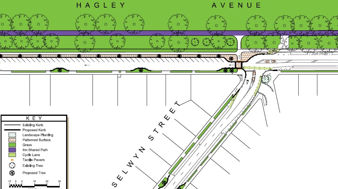
The Major Cycleways are likely to feature a mix of different types of infrastructure for cycling. Some of it will be separated bikeways (especially along busier roads), some of it will be “neighbourhood greenways” shared with traffic along quieter streets, and some of it will be shared pathways along off-road corridors. The latter type of facility has recently been receiving some attention, thanks to proposed plans to develop a widened shared path in South Hagley Park as part of the first Accessible City projects.
.jpg)
Out of the woodwork, a number of groups have expressed concerns about the proposed widened path (which will connect the Little River Link Cycleway from Grove Rd into town), particularly the potential “threat” of sharing with fast-moving cyclists. These issues were raised in the initial consultation process and led to a number of deputations at yesterday’s City Council meeting. In the end, the Council has decided to stick with its original plan to introduce the 4m-wide shared facility (it should be noted that in this particular case, there were also potential difficulties in providing two separate facilities side-by-side due to the impacts on the adjacent tree roots).
I can understand many of the concerns expressed about conflicts on pathways; I experience these personally each day that I ride through Hagley Park on my way to work. Whether it’s a pair of joggers, another cyclist, a mothers’ walking group with prams, or whatever, invariably I will encounter a number of situations where I have to either slow down or swerve off-path to avoid a collision. I use my bell when I think I need to, and usually that seems to result in a clear gap opening up (tip: saying “thanks” as you ride past is good manners!), but it does always feel like I’m imposing on other path users. And I have some sympathy for vision-impaired path users, who may feel even more threatened by the looming presence of a fast-moving bike but not know exactly where it is.
.jpg)
Of course, the main reason that we have to do this little negotiation is because there is simply not enough width provided on most paths in Christchurch. As with most cycling facilities, traditionally we have skimped on adequate space (narrow cycle lanes anyone?) – it would be like building Blenheim Road only 6m wide and wondering why there was so much friction (“well, that’s enough for two trucks to pass, what more do you want?”).
.jpg)
I would argue that most people who are concerned with shared paths are basing their experiences on our (currently poor) existing pathway networks. In my assessment of shared pathways around the city, I can only think of two that I’d say have adequate width/capacity for the peak demands on them: the new Southern Motorway pathway (and that may grow as more people live out there) and the Sumner-Scarborough Esplanade. None of Hagley Park’s paths meet the existing user demand (let alone future growth)… The proposed 4m path for example will replace one that isn’t even 2m wide. A sufficiently wide path can alleviate most of those conflict problems immediately because there is no conflict – everyone has some space. Sometimes that might only need to be 3m wide (enough for three people to go past each other), but if it’s busy enough you will need even more width.
.JPG)
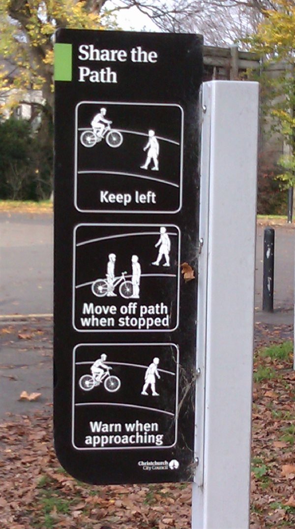
While having a wider path will remove many of your problems, you can also get more out of a path if you encourage people (of all modes) to stick to some simple “rules of engagement”. Things like “keep left unless passing”, “sound a warning before approaching”, “get off the path when stopped” can go a long way towards improving relations between everyone. We’re starting to see a few signs installed within Hagley Park encouraging these behaviours. You can also encourage important ones like “keep left” using simple pathway markings every now and then, like they’ve done in Nelson.
OK, but why not just stick a line down the middle of the 4m and put bikes on one side and pedestrians on the other? Basically it doesn’t provide an optimal solution for either party; both will be squeezed into smaller spaces that won’t always work when groups are present. It also tends to create “turf wars” where people get told off for entering “enemy territory” (perhaps to get around one of those groups). And then along comes the person on a skateboard, or the kid on a trike – which side exactly are they meant to use? No, far better with a single path to separate by direction and encourage people to behave like it was a road – we’re already used to that system.
.JPG)
Still, there must come a point when separated facilities make sense. Yep, just like there’s an upper limit to safely sharing roads between cars and bikes, if path volumes get high enough then separate facilities are warranted. In recent years, research has been undertaken in this part of the world to work just what those “high enough” volumes might be, so now there are useful guidelines from the likes of VicRoads in Australia to look at (we don’t have any NZ-specific guidance, but I can’t see why we would be any different from our Tasman neighbours).
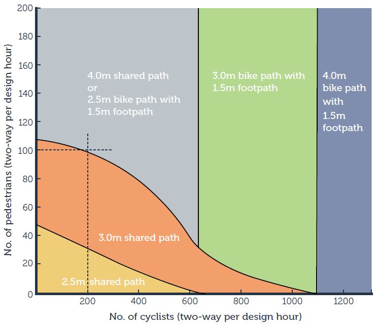
While we would expect the new cycling facilities proposed along Hagley Ave to attract more riders (just being able to get across Moorhouse Ave easily will make a difference for a start), it’s hard to know just exactly how much extra demand we will see along there. Hence the thinking to start with a shared facility and see how the numbers change. If there is a massive increase in path users, and it is clearly causing problems, then Council can roll out an additional pathway to provide separated facilities. Even then, I’m not entirely convinced that people will always use the correct facility – I quite often see pedestrians using the separated bikeways along Tennyson St and Matai St – but if there is enough capacity overall then it may not matter.
.jpg)
It’s clear that there is no consensus on this matter; there will still always be some entrenched “separatists” who don’t believe that shared paths can work and want separated facilities in all cases. However, rather like the same debate that occurs on roads, it not always practical or necessary to provide separate facilities for cycling – and indeed impossible to provide them absolutely everywhere. So for the foreseeable future we will still need to continue to “play nicely together” – and hopefully we’ll have good infrastructure to help make that easier to do.
.jpg)
What do you think about Shared Paths? Can they work?