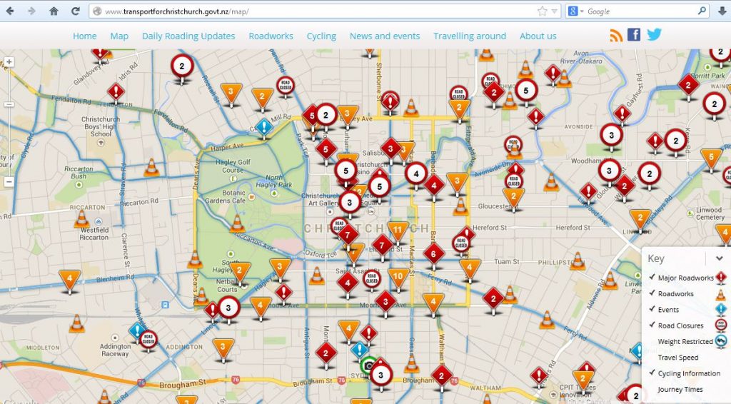
One of the outcomes of the quakes has been a greater emphasis on collaboration by the various organisations involved in delivering transport facilities and services around Chch. Partly this has been driven by the significant upheavals in our transport patterns post-quake, firstly due to land-use shifts/changes and now with the never-ending street works and road closures to patch things up (and occasional storms/floods…). This led to the development of the Chch Transport Operations Centre (CTOC) to oversee all this, and the creation of an overarching website “Transport for Christchurch” (TfC) – there’s also now a smartphone app for iOS and Android.

Obviously a lot of the work that CTOC do is focused on how to move motor traffic efficiently and safely around the city. But they also acknowledge the very important role that other transport modes make to keeping this city moving, and that includes cycling. The cycling part of the TfC website contains a variety of information, including:
- An interactive map of cycle facilities (lanes, paths, etc) and real-time updates about major works and road closures
- You can also get PDF versions of the Chch Cycling map for printing out
- Information about how to use some of the special cycle facilities available, like hook turns and advanced stop boxes
- Links to info about the Cycle Design Guidelines
- Safety advice for riders when dealing with traffic (and vice versa)
Staff from the travel information team with TfC have recently had discussions with key cycling stakeholders over the provision of information on the website. They are keen to know what is useful, what’s not, and what is missing. For example:
- Oddly, in this age of social media, there doesn’t appear to be any Facebook or Twitter sites for TfC (although the #chchtraffic hashtag gets used a little bit by CCC and SCIRT on their Twitter feeds).
- The cycle map shows all the cycle lanes and pathways in great detail across the network. However it doesn’t indicate what are suitably quiet streets that can also form part of cycling routes; thus, to many, it may look like there isn’t a complete safe route to where they want to go.
- Many of the supposed “road closures” on TfC are really only closures for motorists; pedestrians are often still provided for (and usually, by implication, bikes can also get through). The notes that go with each of the closures on the map can indicate specifically “pedestrians/cyclists affected”, but I’ve found in my experience that in many of these cases you can still get through (i.e. you may be “affected” by having your path changed but you still have access). So there needs to be some better clarity around this.
- Even better would be a journey planner that could let you know what is the recommended route given all the various closures, and depending on the mode you choose. GoogleMaps is probably your best best for that at present, but they are reliant on all the current road closures being recorded (they’re pretty good, but not perfect).
It may be that some of this information is best collected by “crowd-sourcing”, i.e. using the collective wisdom of the public to highlight the good and bad stuff (and when it changes). We’ve already highlighted some examples of that before via GoogleMaps and FixMyStreet. There are also some notable examples overseas where similar initiatives have been used to help identify the best/worst places to ride, such as in Berlin and Melbourne. It may be that we can even come up with a clever way to link it to Cycling in Chch, so that we can provide yet another useful service to you – I’m happy to talk to anyone interested!
If you can think of some other ways that TfC could provide better useful information for people cycling, put your comments here and we’ll make sure that the TfC staff see them.
What do you think of the TfC website? What would you like to see on it?

While the TfC map is comprehensive, I find it of little use in practice. It’s not easy to see at a glance which roads are closed, because it aggregates the icons at wider scales, and you then have to manually check the whole route. Much more effective would be to share all of the information with Google Maps so that it can integrate it into its route planning (which it already seems to do, but I’m not sure to what extent). If that’s not possible, then as suggested above, perhaps it’s possible to incorporate Google’s route planning into the TfC map (which must include the ability to vary the route).