
Occasional guest blogger Jim Pickles has a few observations from overseas that could be applied to Christchurch…
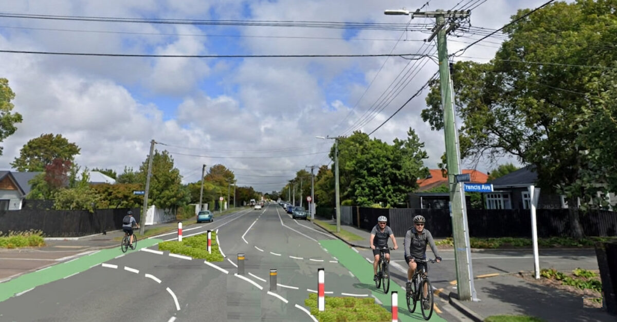
Over recent years there have been extensive additions to Christchurch’s cycling network. At the same time some of the local streets that make up the beginning and end of most cycle trips, have been getting busier and unless this is fixed growth in cycling numbers will be affected.
In Amsterdam, about 80% of all streets are considered as local streets and don’t have any specific cycling infrastructure, but almost all of them have a 30km/h speed limit. This is considered low enough to discourage through traffic. If necessary, other measures are taken such as limited access points from main roads, physical barriers and various road designations prioritising cycling and walking over motor vehicles. As a result, any cycling trip in Amsterdam can be taken in safety and comfort from end to end.
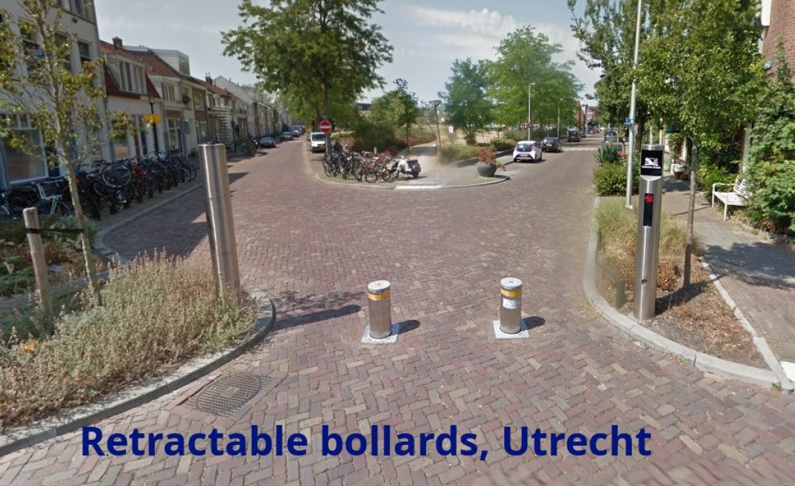
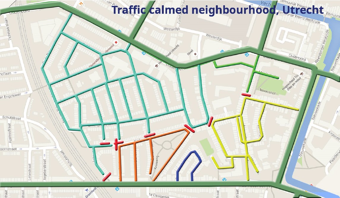 In Utrecht, a block that needed extra treatment to prevent through traffic was calmed by using a mixture of fixed and retractable bollards. Local residents weren’t inconvenienced but through traffic across the whole block was stopped. All of the surrounding main roads have on-street or separated cycleways.
Low traffic neighbourhoods (LTNs) are being created in cities around the world, often in inner suburbs where heavy traffic on local streets was increasing noise, pollution and accident risk. They grew quickly during the Covid epidemic as a way to allow safe walking and cycling close to home and they also helped people to avoid crowded public transport and the risk of infection. Since Covid they have continued to increase in number.
In London, where each borough is responsible for its own local streets, there has been a wide variation in the number and scale of LTNs introduced. Traffic data shows that the boroughs with the most LTNs have the highest cycling rates and the lowest levels of traffic accidents. Many longer trips can be taken safely by using a combination of cycleways and LTNs.
Could LTNs be used in Christchurch as they have in other cities in combination with cycleways to increase the number of people cycling, not just locally but on longer trips? If so, this could possibly be achieved faster and at a lower cost than other options.
There is a much higher dependency on cars here than in European cities where public transport is well developed. Local residents would oppose any scheme that caused them inconvenience when driving. Fixed bollards or one way streets that resulted in detours would be very unpopular.
 As in Utrecht, LTNs have been created in several cities with the use of retractable bollards. Number plate recognition using cameras lowers the bollards for residents so there is no impact on their journeys at all. Vehicles from outside the area don’t trigger the bollards so they can’t use the area as a short cut. The cameras are linked to vehicle ownership data held by the city council. There would be no additional admin cost for the city when someone moved house or bought a new vehicle, as Waka Kotahi updates the information.
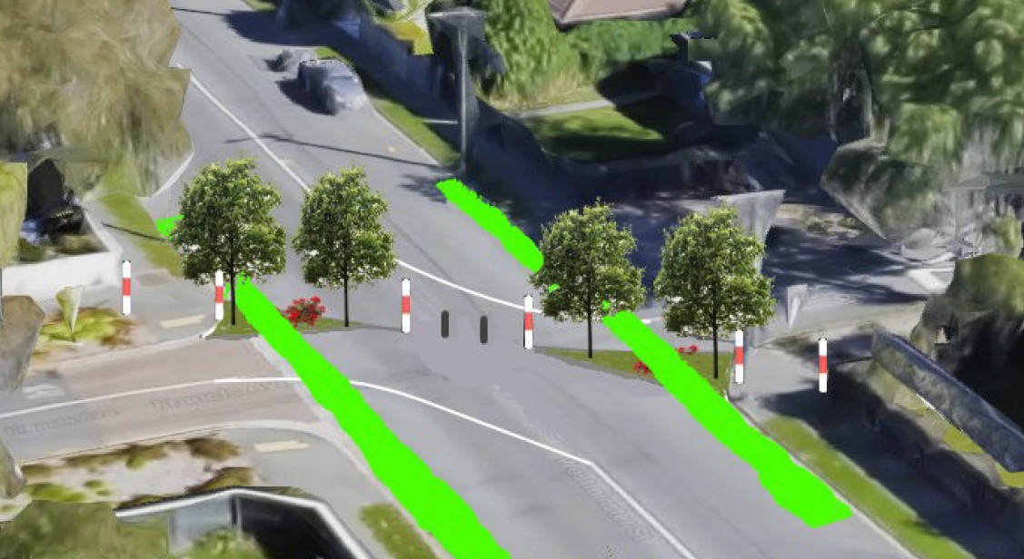
Because of increased traffic on local streets in our area of St Albans/Mairehau following the opening of the Northern Corridor, the city council has already had to consider what to do under the Downstream Effects Management Plan (DEMP). After many years of consultation and planning Flockton Street is being worked on right now at a cost of around $5m and is due to take around eight months to complete. When asked “Will traffic volumes on the local streets ever lower to numbers before the Christchurch Northern Motorway once the roadworks are completed?” the council replied “The short answer, no.” Could better cycling conditions have been achieved faster and more cheaply using retractable bollards similar to those used in Utrecht?
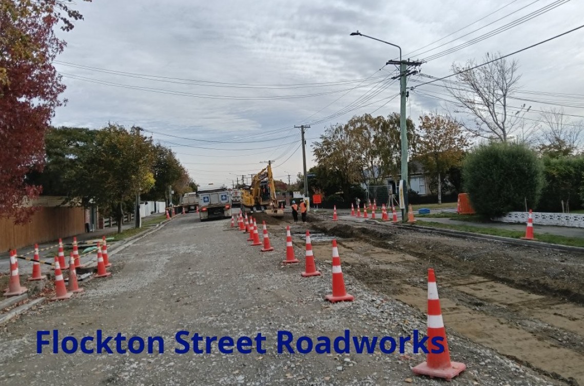 Flockton St is in a block bordered by Cranford St, Warrington St, Hills Rd and Innes Rd. The closing off of Forfar St has made it very easy to traffic calm the whole block with just three sets of retractable bollards for a total installed cost of about $200,000 compared to the $5 million for the Flockton St work. While the Flockton St work is accepted by the council as making very little difference to traffic volumes, the installation of retractable bollards would reduce traffic by around 70% to 80% and remaining traffic would all be local. The weak link at the start and end of longer cycle trips made by local residents would be fixed and cycling within the block would become a pleasant experience.
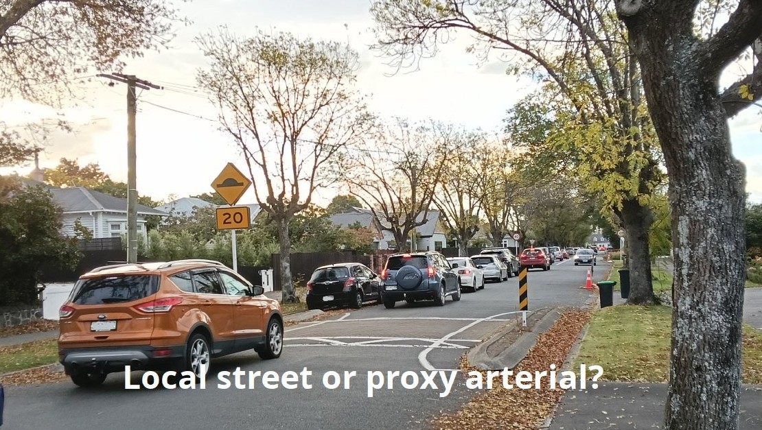
There is a longstanding tradition of “rat-running” through the inner suburbs of Christchurch to avoid queues on arterial roads, especially at traffic lights. Several factors have combined to make things worse.
- Rapid residential expansion beyond the city limits following the 2010 and 2011 earthquakes.
- New motorways both north and south of the city.
- Google Maps’ traffic layer started to highlight slow routes which made them easier to avoid.
- Most new vehicles now have built in satellite navigation (“satnav”).
In-car satnav is now almost exclusively used for avoiding jams. Trips between work and home are when satnav is used most:
- 78% of the traffic on our local street is “rat-runners” using the residential block as a cut-through.
- Most of the through-traffic is the result of drivers avoiding delays at surrounding traffic lights.
- During rush hours, the through-traffic increases to 85%.
- 70% – 80% are using satnav.
- Some of the others are spotting heavy traffic on Google Maps and making their own decisions as to how to avoid it.
In other words, the vast majority of traffic using local streets in this neighbourhood is simply cutting through and almost all of them are using satnav to find their quickest route. The satnav algorithm won’t stop sending people through unless the route is physically impossible for the software to ‘see’ it as a through-path.
After the Flockton St roadworks, all streets in the area will still be seen as potential short cuts by satnav apps. Any street that has access at both ends is considered by the satnav algorithm. Traffic will be slightly slower on Flockton Street but, if there are delays on the surrounding arterial roads, it will still be selected by satnav. Other local streets will be recommended slightly more frequently. In other words, it will have virtually no impact.
Are there any problems using retractable bollards instead?
- Buses, emergency vehicles, refuse trucks and other council vehicles. The usual way to handle this is with transmitters, which automatically lower the bollards on approach.
- Visitors and tradespeople. They would still have access but would need to take a longer route in some cases.
- Faulty mechanisms. Retractable bollards are very reliable but, if they failed and wouldn’t open, then all residents would still have access in and out of the block.
- Accidents and roadworks. If there was a blockage on surrounding arterial roads due to an accident, construction work or roadworks, then the bollards could be kept open until the blockage was cleared.
- Safety. Care needs to be taken in the selection of bollards to make them easily visible both day and night.
- Local business disruption. Almost all of the businesses and all of the shops are on the edges of the block within a few metres of the surrounding main roads.
- Communications. There needs to be thorough communication and consultation with all people affected to avoid what happened at Onehunga, Auckland.
- Surrounding main roads. Traffic will increase by 3.5% to 5.5%, similar to day to day fluctuations.
If nothing is done, there are several factors which will continue to make things worse:
- Google is currently rolling out the biggest update to its satnav in 10 years which will make it even more attractive to use.
- Nearly all new cars now have satnav as standard equipment.
- All satnav companies are incorporating AI into their software to make it more effective at finding faster routes.
- Competition between satnav suppliers means that they are always looking to be the one that saves drivers the most time.
- As EV uptake accelerates, the cost of long commutes will drop to a fraction of current costs and encourage residential development beyond the city limits.
The traditional road hierarchy where arterial roads are for longer journeys and local streets are used by local residents means little or nothing to satnav. Any local street with access at both ends is a potential arterial and satnav will use all available streets to spread the traffic load as evenly as possible. Road humps and chicanes no longer make a noticeable difference.
 If the use of retractable bollards was expanded throughout the inner suburbs and, along with safe signalised cycle crossings over main roads to link them together, they could make a strong contribution to the cycling network. Signalised crossings are expensive at around $500,000 a time but despite this, all inner residential suburbs could be calmed and linked in this way quickly and at a cost well within the city council’s active travel budget. The cost of calmed roads in this block would be about $20,000 per kilometre while cycleways cost about $3 million per kilometre.
Note: AI was used to calculate some of the stats in this article.
Should we make more use of Low Traffic Neighbourhoods in Chch?
I love your suggestions, but I am afraid that you may start a riot in our car centric city. On of the things I noticed cycling in Amsterdam was that it was less about the infrastructure and more the sheer number of cyclists giving safety in numbers. Chicken and egg, I know!