I’d better mention this interesting development that is currently out for consultation (closing Friday) – I didn’t even know that this project was in the pipeline until it came out a few weeks ago. But it features A LOT of cycling infrastructure in what is currently quite a busy area.
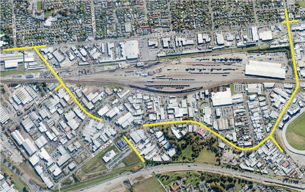
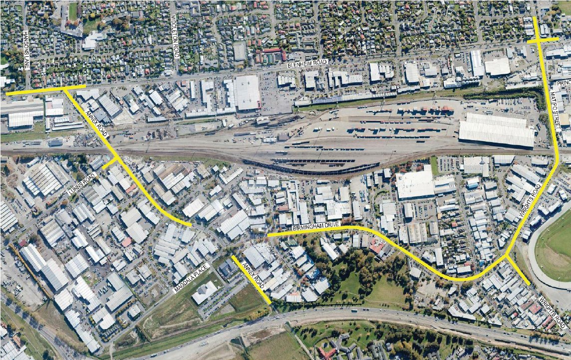
The Christchurch City Council is planning to upgrade Annex Road, Birmingham Drive, Wrights Road and Matipo Street, to cater for better traffic operations. While the area is already fairly hectic, that is likely to get worse when the planned Wigram-Magdala overbridge links over here from the west (new intersection at Annex/Birmingham).
The Annex/Birmingham/Magdala signalised intersection has already been consulted on and programmed for construction in a couple of years; this current project is consulting on treating the surrounding streets before it gets built. There are a number of interesting features; looking from west to east (see the full CCC plans for more details):
- An additional right-turn lane on Annex Rd at the the traffic signals when joining Blenheim Road, plus a longer turn lane from the Hansons Lane intersection. This means that the westbound cycle lane will be directed onto the adjacent shared path to get through these intersections.

- New traffic signals at the Annex/Lunn intersection near the railway crossing, with a mix of cycle lane and path treatments in the vicinity.

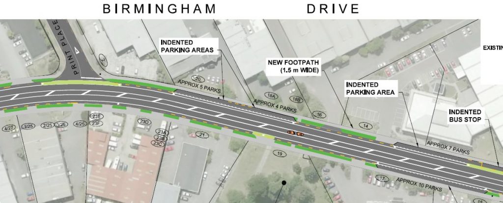
- New cycle lanes along Birmingham Drive, Wrights Rd and Matipo St, with some indented car parking. There’s a few curves along there though – will motor vehicles cut corners?
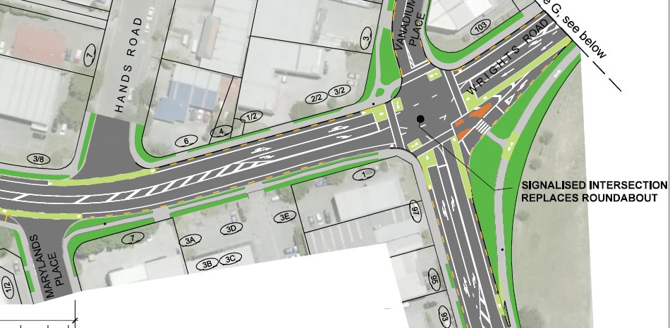
- New traffic signals at the Birmingham/Wrights intersection (current roundabout). As well as cycle lanes, note also the cycle slip lane around the corner, as well as advance stop boxes and hook turn boxes.
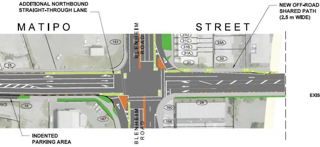
- An extra northbound through-traffic lane at the Matipo/Blenheim intersection. As well as cycle lanes, there are also some hook turn boxes and a short section of off-road path (apparently pedestrians only cross on three sides though…).
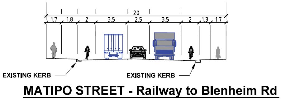
- In most cases, the road space will be reconfigured to include a (typically 2.5m wide) painted median, 3.5m traffic lanes, and 1.8-2.0m cycle lanes. On-street parking will still be provided where space permits but a lot will go – only about 160 of the existing ~330 on-street car parks in this area will be retained.
So, what do I think of these proposals? Well, it’s great to see additional provision for cycling along these busy corridors; as well as serving destinations in this area, there’s also a lot of people who link through here from Upper Riccarton to/from Spreydon and Hoon Hay. The signalised intersections should help with crossing these busy roads and it’s nice to see quite wide cycle lanes provided. Good to see some new footpaths and pedestrian crossings too (would be good to see more central islands though, especially near bus stops).
I do wonder though how this fits in with the planned “Nor’west Arc” Major Cycleway that’s meant to run approximately along the Annex Rd corridor – the proposed facilities are clearly not at Major Cycleway standard. So are they only temporary in some places?
In fact it’s rather confusing what is being provided in some cases (especially along northern Annex Rd); there is quite a jumble of on and off road facilities that don’t seem particularly coherent to a rider. While it’s great that, for example, the Annex/Lunns intersection will provide “dedicated traffic signals to separate pedestrians and cyclists from conflicting vehicle movements”, I’m still not clear how exactly I’m supposed to get through this intersection in an efficient manner.
Another opportunity that would seem obvious is to include cycle lane separators at a number of intersection approaches and on the inside of curves. Annex Rd and Birmingham Dr for example are quite curvy, so separators would help to prevent motor vehicles from cutting the corners.
Consultation closes 5pm this Friday 12th Dec. If you have any thoughts get your feedback in now!
What do you think of these proposals?

A couple of things seem missing.
1. How is one to get across annex road near Blenheim road if you are heading toward Hoon Hay. This is an important route to get from the west to the hills.
2. The annex road intersection with Birmingham drive is a real danger point for cyclists but there is no detail.
I believe the preferred way to get across Blenheim Rd would be via the widened shared path that goes around the corner. You’ve got signals at Hansons Lane and will get signals at Lunns Rd to cross back over.
As for the Annex/Birmingham intersection, the consultation documents do show you what that will look like (signals, cycle lanes/paths/etc). But that was consulted on previously (as part of the Wigram-Magdala Link Rd), so hasn’t been shown here. Cyclists should find it a lot easier because of the change to their route south being a true “through” movement (rather than a right-turn across traffic).
Thanks for your reply, was wondering the same.
I also am also wondering what it going to happen with the trains crossing Annex Rd – currently these are at peak times and if block Annex Rd for >15mins (I have personally witnessed this only a month ago), the wider impact can jam intersections in the area and take a while to clear. Collaboration with KiwiRail is needed. An overbridge would be best in the longer term.
ah right thanks for clearing those two points up. I use this route regularly and have been quite concerned about it. I look forward to the changes.