
Given the rapid rate of knots that new cycleways are being built around the city right now, you could be forgiven for not keeping up with the best routes to get around by bike. And if you suddenly change your home or workplace, you might also be a bit disoriented until you get to know the new lay of the land. This post, originally from Nov 2013, gives you some hints about how to find a new best route, be it by getting out on the streets (the cycle route signage is getting better too) or just searching electronically (these days I would be more inclined to recommend OpenStreetMap over GoogleMaps though if you want the latest transport facilities):
So, as I mentioned previously, I’ve just moved house and that means a new ride to work and other destinations. It can be a bit disorienting at first to work out the best way to/from each place. So how do you determine how to get there by bike?
A map is a good place to start; it could be a simple paper map or an electronic one. Here on Cycling in Christchurch we have a webpage of handy advice for where to ride, including various map links. One method that’s starting to get more useful in Christchurch is Google Maps‘ cycle route directions. Just enter your start and end destinations, click on the bike logo and get some directions for riding there.
The only problem with Google Maps is that it depends on how good the information is that Google has on cycle facilities. Slowly the various bits of Christchurch’s network have been added, so you can see most of the cycle lanes, pathways and other “bicycle friendly roads” available around the city. But still there are occasional quirks in the system, so you need to take the suggested routes with a little bit of care.
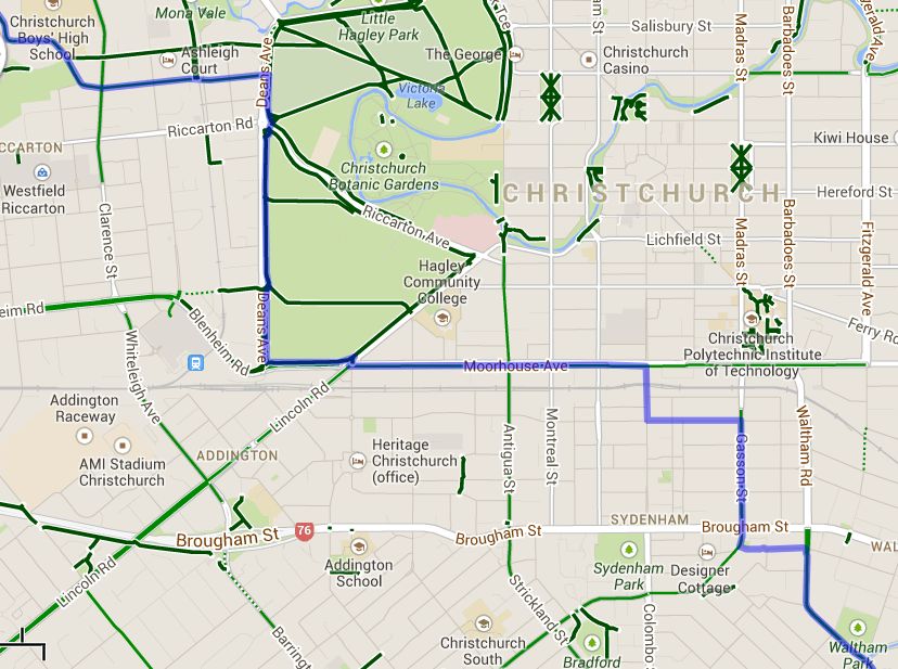
In my case, the initial route by bike suggested by Google included a large chunk of Moorhouse Ave and Deans Ave; not that friendly. But my actual preferred route is via Strickland/Antigua Sts and alongside Riccarton Ave. If you select the suggested blue route with your cursor you can drag it to other streets to force the route to go certain ways. However, even doing that, Google appeared to have gaps in available cycle routes along Antigua St (maybe because of all the recent road closures there?) and on Tuam St by Hospital Corner (because the cycle links weren’t coded there).
Luckily you can report any problems directly to Google to fix up, or you can even try to resolve them yourself using Google Map Maker (e.g. I went and added the missing link on Tuam St) {sadly, MapMaker is no longer; all you can do is report changes/errors to Google}. The end result is that my actual route is only 9.7km (vs the originally suggested 10.5km), including Tennyson St cycleway and the Hagley Park paths. I’d suggest that you try out a few different options using Google Maps and then perhaps compare them on the ground.
If you’re not sure about your new route, you might want to try it out first on a weekend to make sure that you are completely familiar with it. This is also a good way to work out how much time it might take, especially if your destination is time-critical. As well as distance, Google Maps gives an indication of biking travel time but I find they don’t necessarily match your riding pace. A word of warning: a weekend ride may not quite prepare you for the traffic during rush-hour (or the delays you might encounter trying to find gaps in this traffic).
Talk to your friends, workmates, new neighbours etc as well and see if they suggest any preferred places to ride. And there’s no rule that says you can’t change your route if you don’t like the first one (you might even use a slightly different one for the return trip, perhaps because of a tricky intersection). Christchurch is largely a grid-based network, so usually there is a reasonable alternative route not too far away.
A major life-change like moving house or changing workplaces is often a great opportunity to change how you get around. Travel behaviour planning often focuses on these scenarios to get people to look at whether they could use more sustainable travel options. Given that workplaces and residential areas in our city are continuing to shift around during the rebuild, and with the planned citywide roll-out of cycleways, many people’s travel habits could change over the coming years.
What are your top tips for finding your way around a new place by bike?
Just remember the best route for a car is not the best route for a bike, and consider paths and parks.
The example works okay if you use the pathways inside Hagley park now, which are sealed all the way around the perimeter, then onto Grove Road where’s there’s a great cycle lane. The Brougham Street crossing is a bit terrifying – don’t assume cars are stopping for a red.
But that all shows up “local knowledge” as being a great source of routing info. Other people at work who ride in the same general direction, ask them for suggestions.